Charlestown Watershed Master Plan (WMP)
This project will perform hydrologic and hydraulic analyses within an 8-square mile sub-watershed of the North East River to forecast flood vulnerabilities for a range of extreme precipitation events for current and future land use scenarios. The results will be evaluated to create a plan that will identify and design strategic stormwater system improvements, which may include new green and gray infrastructure projects. This plan will also compare updated stormwater runoff scenarios with sea-level rise and storm surge scenarios in the coastal portion of the watershed. The WMP will be developed that identifies recommendations for potential changes to stormwater management regulations, areas to improve upon the existing drainage system infrastructure, designing new structural and non-structural practices, as well as, identifying procedures to establish stormwater easements on existing lots of record and protect and/or acquire sensitive natural areas and flood-prone properties.
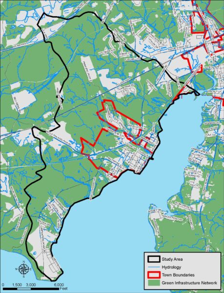
Study Area Map
(Click for larger image)
The WMP will explore opportunities and potential partnerships to protect, improve, and expand natural lands that can function to improve the capacity to manage intensified precipitation and its accompanying stormwater run-off and flooding. The Town of Charlestown will be partnering with Dewberry Engineers to prepare the mapping assessment and draft plan. This project will lead to a functional plan that supplements the Comprehensive Plan, and will aid with future policy direction.
Final WMP
Watershed Master Plan Tech Memo FINAL March 2024
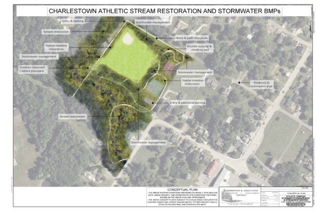
Project Implementation
The Commissioners of Charlestown held a public hearing on Tuesday, June 18, 2024 at 6:00pm at the Charlestown Fire Hall, 307 Market Street, and via Zoom. The below concept plan for the design and implementation of a stream restoration project around the Town’s Athletic Complex, including the creation of stormwater management demonstration projects in and adjacent to the park, was reviewed. Click the links below to view the video or read the approved minutes.
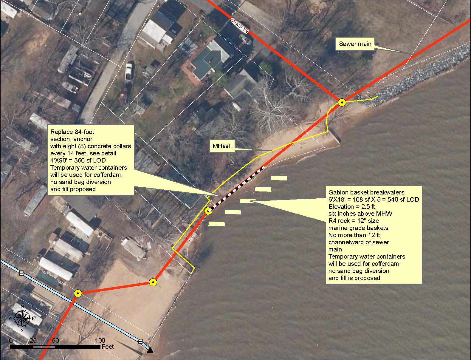
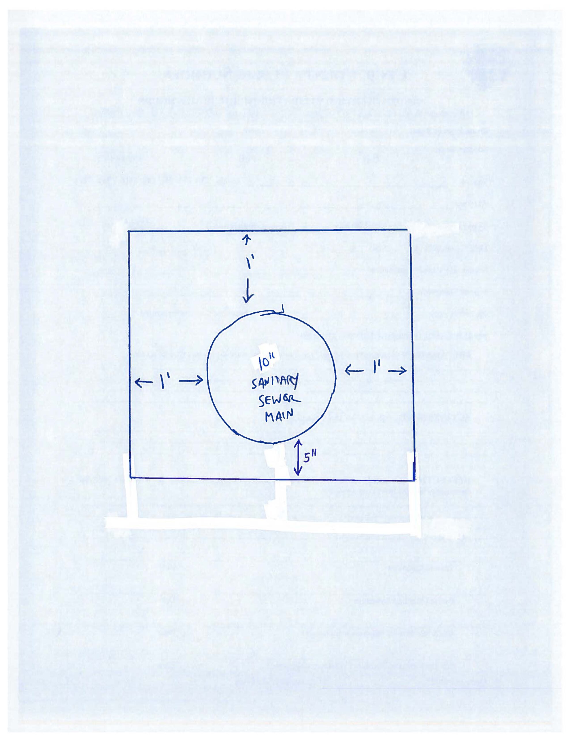
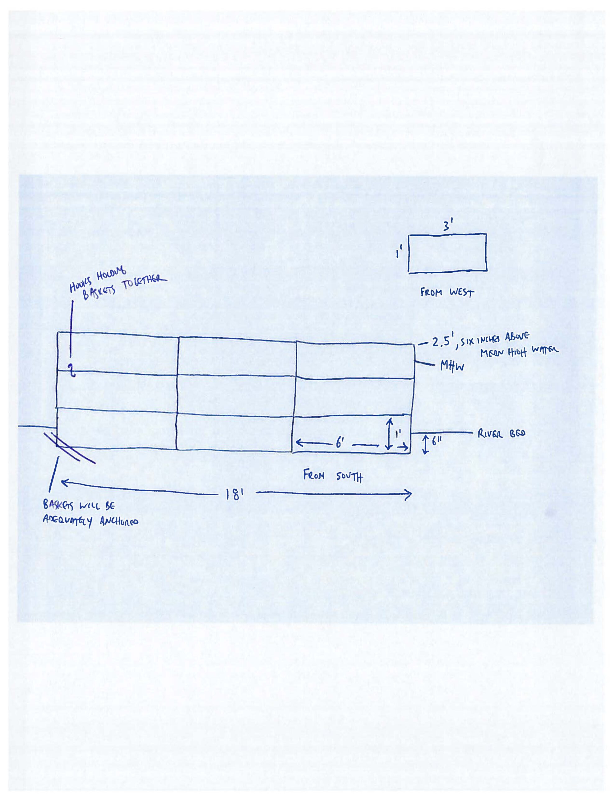
Tasker Lane Sewer Main Replacement & Protection Project
This stretch of shoreline had eroded around the sewer main, and in addition to replacement, the Town will help protect the sewer main from future erosion, by installing offshore rock breakwaters, which will help to reduce wave action impacts, while at the same time, help to maintain natural beach nourishment.
Click below images to view larger, or view as PDF.
Project Memorandum from Dewberry
The memo describes what we’re looking at for six different flooding scenarios (rainfall and tidal conditions). Each video (see below) is a 60-second time lapse of the flooding that occurs over a 24-hour period. The middle third, or 20-second middle part of the video, tends to be when the flooding is the deepest, lasts the longest, and has the highest velocity. During the next Community Workshop of Monday, June 5 at 6pm, we will review some of the videos, and ask ourselves some of these questions:
- Do the videos accurately depict the flooding we’re currently seeing?
- Do the method and results make sense?
- Are the videos helpful for identifying community problems, as opposed to, just individual property problems?
Our goal for the June 5th workshop is to help create a common sense of understanding of the modelling results, so we can start creating ideas on what to do about the community flooding challenges, such as regulatory changes, incentive programs for projects on private properties, and project ideas themselves. After we synthesize the results of the feedback from the workshop, we’ll finalize more of the technical details of the priority mitigation action and project list, using our prioritization criteria, including flood threat level, critical infrastructure projection, and maintaining access to the Town. We anticipate the draft plan being available for review by the end of August.
(Click the image below to enlarge.)
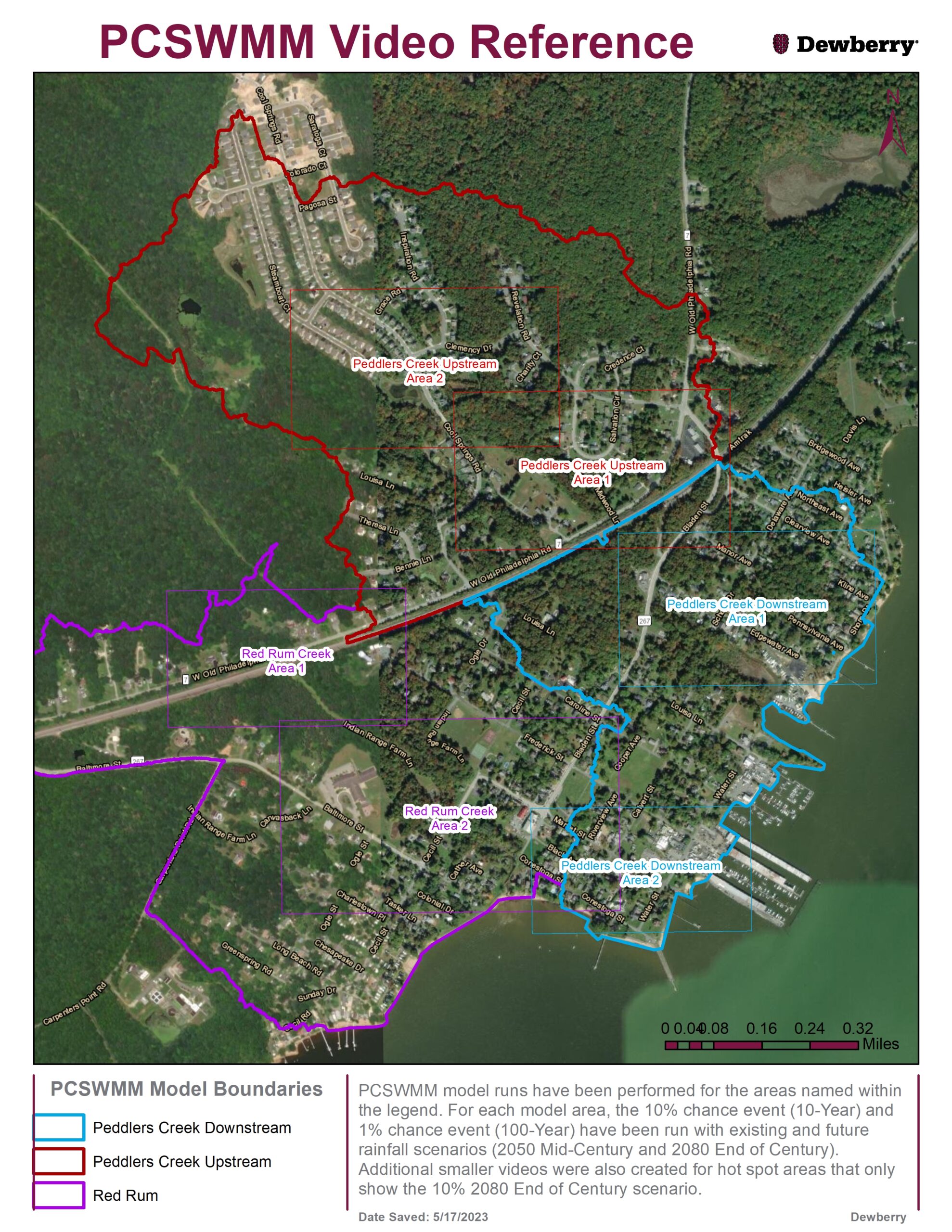
Video Scenarios
Peddler’s Creek – Downstream – Area 1
Peddler’s Creek – Downstream – Area 2
Peddler’s Creek – Upstream – Area 1
Peddler’s Creek – Upstream – Area 2
Red Rum – Area 1
Red Rum – Area 2
Resources
RESIDENTS: Please use the MyCoast webpage to help us document the flooding you might be experiencing, including tides and storm damage. The Town can use this information, along with other emergency managers, to make better decisions.
For more information, please contact Town Hall at 410-287-6173 or staff@charlestownmd.org.